Slider

slide1

Drone Structure Scan - Derelict Cottage

Detailed 3D model of and old derelict cottage in Midvale.

slide2

Small Drone Mapping 101

The Aero Scout shares his experiences with drone mapping and 3D models.

slide3

Arthur River Mt Pleasant Kitchen - 3D drone structure scan

3D model of the heritage building Mt Pleasant Kitchen in Arthur River.

slide4

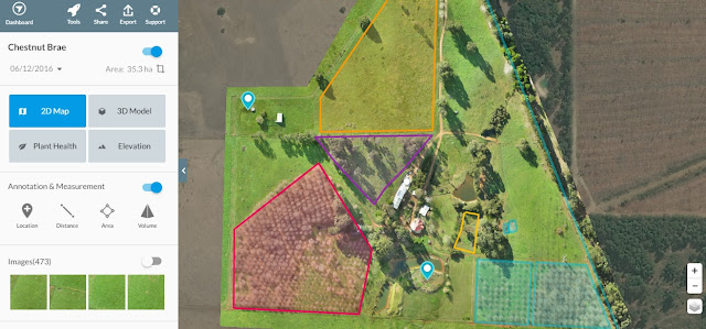
Chestnut Brae - Farm planning map in Nannup

Demonstrating how drone imagery can be used as a base for effective farm planning.

slide5

Drone Structure Scan - Heritage Lighthouse

Drone structure scan of the heritage South Mole Lighthouse in Fremantle.

Gidgegannup Farm - Crop health monitoring

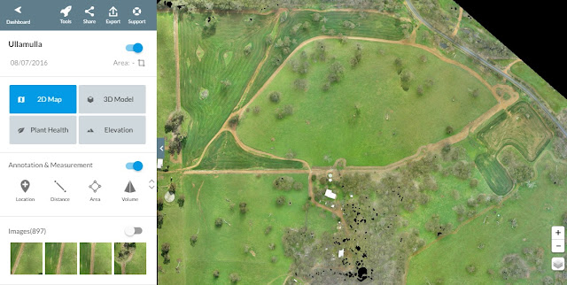
Gidgegannup Drone Scan Crop Health Monitoring using Drone Deploy
Crop health monitoring showing .....

Drone Scan - Crop Health Monitoring

Demonstrating plant health monitoring based on drone imagery processed in Drone Deploy.

Mission Summary

  • Goal:  To demonstrate how a 'plant health' map can be used to assist in crop management
  • Tech: Skyray fixed wing drone, Canon S100 camera, Tower app, Drone Deploy
  • Conditions: Midday and stormy
  • Outcome: Drone imagery enables quick and accurate analysis and it also shows the larger field-scale trends that can go unseen at ground level 

Through a close friend I was able to head over to Gidgegannup, just outside of Perth to demonstrate the effectiveness of using a drone to create a 'farm management' map, including 0.5m contour lines. Whilst the morning was sunny and fine, there was a storm front on it's way, lucky for us we were able to map a 200 acre section of the farm before the storm arrived and still sit down to a delicious warm roast lunch. I was also able to capture imagery of recently seeded oats that would be used to feed the livestock during summer. This was a great opportunity to show how even a basic 'plant health' map can be used to assist a farmer in not just the planning side of the farm but also the management of it's assets.

Gidgegannup Drone Scan Crop Health Monitoring using Drone Deploy

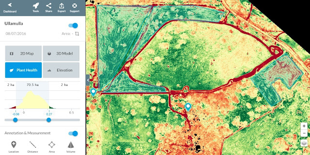
Using Drone Deploy's 'Plant Health' feature, we were quickly able to visualise the crop health of the oats in four regions, based on the RGB imagery using the VARI algorithm. Each region had an 'area' placed around it to help identify and accurately measure.

Gidgegannup Drone Scan Crop Health Monitoring using Drone Deploy

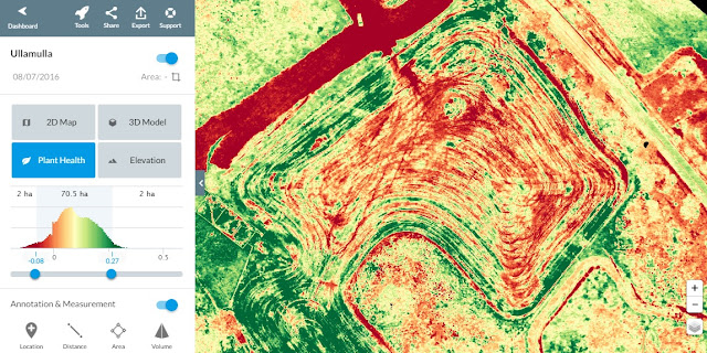
Zooming in on each of the zones it was easy to see the areas where the crop was struggling and where it was thriving. Being able to see areas of possible trouble is a huge plus for this farmer in accurately monitoring and assessing the crop.

Gidgegannup Drone Scan Crop Health Monitoring using Drone Deploy

Understanding the history to each zone was critical, the zone below was seeded the same day that the rest of the zones, however it is clearly not doing as well.  There are many reasons that could caused such a difference, poor seeding practices, lack of nutrient or water. The imagery is only giving an indication that there is a problem, it cannot diagnose (yet) what the problem is, this is where ground truthing is always recommended.

Gidgegannup Drone Scan Crop Health Monitoring using Drone Deploy

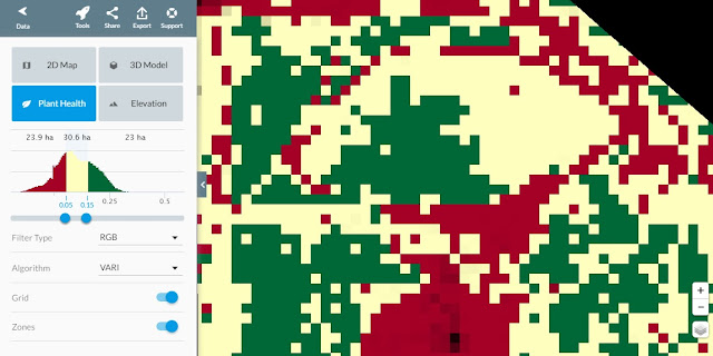
Using the 'Zones' tool we can simplify the 'health rating', this in turn can create a 'Grid' which can then be as a prescription chart for variable spraying of fertilisers etc


Gidgegannup Drone Scan Crop Health Monitoring using Drone Deploy

Gidgegannup Drone Scan Crop Health Monitoring using Drone Deploy

The above is an analysis based on RGB imagery, however using an NIR filtered camera would produce more accurate results using the NDVI algorithm. With this more detailed analysis too it's possible to calculate crop biomass, nitrogen deficiency, disease, drought, pest infestation, salinity, and more. Understanding this can save a farmer money because it enables them to apply fertilizers, pesticides, and herbicides only when and where they are needed.

This has been another 'drone adventure' in aerial surveying, inspection and mapping by The Aero Scout.

Quarry and housing development - 3D drone map


Drone mapping a quarry and new housing development

Mission Summary

  • Goal:  To create a 'drone map' of a quarry and housing development
  • Tech: Skyray fixed wing drone, Canon S100 camera, Tower app, Drone Deploy
  • Conditions: Midday, sunny, nil wind
  • Outcome: 50 hectares where successfully mapped in 14min. :)

I found an excellent site that was going to allow me to demonstrate how a drone map can assist both a quarry manager and a housing development manager with planning and monitoring of the site.

2D map of the quarry (left) and new housing development (right) created with drone images
Elevation visualisation of the quarry and housing development

3D view of the quarry and new housing development
This has been another 'drone adventure' in aerial surveying, inspection and mapping by The Aero Scout.

Chestnut Brae - Small farm planning map


Chestnut Brae Drone scan Small farm planning map using Drone Deploy - Image 1
Comparison of drone image clarity (within property boundary) with low resolution satellite image (outside propert boundary).

Overview

  • Goal:  To demonstrate how drone imagery can be used as a base for effective farm management
  • Tech: Skyray fixed wing drone, Canon S100 camera, Tower app, Drone Deploy
  • Conditions: Mid afternoon, overcast with nil wind
  • Outcome: The drone imagery provided excellent resolution and Drone Deploy provide great tools for conducting detailed farm management and planning 
Recently I went down to see Linda and John Stanley of Chestnut Brae, an 80 acre chestnut farm in Nannup, south western Australia. I wanted to demonstrate to them how good quality drone imagery, along with an online service such as Drone Deploy could be used as the base of an effective farm management and planning tool.

Chestnut Brae Drone scan Small farm planning map using Drone Deploy - Image 2
Running a drone mission at Chestnut Brae to create a farm planning map.
Some basic needs of farm planning and management are being able to determine distances, areas and volumes or different aspects of the property. Traditionally this would mainly be done by going out into the field and physically measuring it or perhaps by using low resolution satellite imagery printed onto an A1 laminated poster of the farm.

However its now possible, using low altitude drone imagery coupled with an online user interface, for farmers such as John and Linda to use a tablet or laptop to very easily to zoom in and out of a high resolution map of their property. Zoom levels are far greater than satellite imagery which make using the distance measure, area and volume calculating tools plus much more very accurate, this helps to take the guess work out of farm management ..... all from the comfort of their living room.

See listed below examples of some of the uses of such tools:

Chestnut Brae Drone scan Small farm planning map using Drone Deploy - Image 3
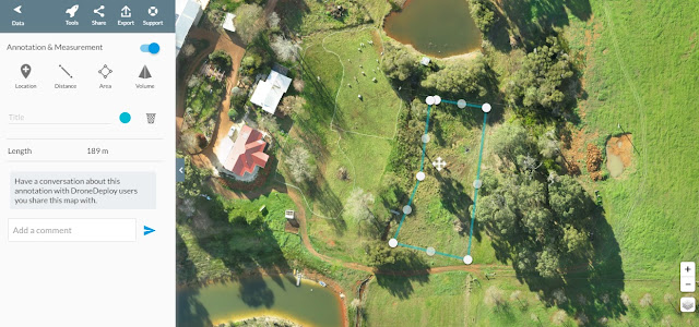
Using the distance tool it's simple to measure the length of the east boundary to get easy estimate of materials for an accurate quote on building a new fence.

Chestnut Brae Drone scan Small farm planning map using Drone Deploy - Image 4
A mobile electric fence is used for penning the sheep, each fence segment is 50m long, why not quickly measure the perimeter of the proposed next location before moving it? This helps take the guesswork out - see length measured in sidebar.

Chestnut Brae Drone scan Small farm planning map using Drone Deploy - Image 5
Measuring the total area of the east orchard - see details in sidebar. Also trees can be counted and health assessed.

Chestnut Brae Drone scan Small farm planning map using Drone Deploy - Image 6
Why not segment the east orchard into two to get a more accurate area of the older trees vs the younger chestnut trees?
Chestnut Brae Drone scan Small farm planning map using Drone Deploy - Image 8
Dropping an elevation marker on a proposed location for a windmill lets us easily determine the head height to the tank at the top of the farm - The tank has an elevation of 245m, see the windmill location elevation in the sidebar. 
Chestnut Brae Drone scan Small farm planning map using Drone Deploy - Image 9
The high resolution of the drone map means that zooming in to calculate areas of paddocks is far more accurate than satellite.
Chestnut Brae Drone scan Small farm planning map using Drone Deploy - Image 10
The volume tool helps with calculating both cut and fill volumes - see the values listed in the sidebar.
Chestnut Brae Drone scan Small farm planning map using Drone Deploy - Image 11
Overall farm plan showing distances, areas, volumes, elevation markers all created from drone imagery and Drone Deploy.

Elevation

It's not always easy to understand the different elevations on a property, the Drone Deploy 'elevation' tool makes it clearer using a colour gradient. The values shown in the colour gradient can be adjusted using the histogram to get a better view of the elevations. This kind of tool enables a land owner to better place assets such as header tanks, drainage trenching and dams, plus with the addition of contours gives the accuracy needed for regenerative agricultural techniques such as keylining.

Chestnut Brae Drone scan Small farm planning map using Drone Deploy - Image 12
Using the 'elevation' tool is a great way to easily visualise the rise and falls on the farm.

Plant Health

The plant health tool is great for a basic visualisation of plant health on the map and can be used to determine when and where to move stock around the farm. This tool, when used with RGB images (normal photos) uses what's called a VARI index, it is a measure of "how green" an image is. For more accurate data on plant health an NIR camera can be used when flying the drone, this will provide more meaningful data when the NDVI index is applied.

Chestnut Brae Drone scan Small farm planning map using Drone Deploy - Image 13
The plant health tool shows areas of paddocks with fuller growth of grass and pasture.
Drone Deploy Logo

3D View

Whilst not necessarily a tool for farm planning, as part of the process of generating drone imagery often a 3D view is produced. Because the imagery is based on a top-down view trees aren't usually modelled very well, they look 'ghostly' like a weeping willow. But even with this shortcoming a 3D view can still have its uses.

Chestnut Brae Drone scan Small farm planning 3D map
A 3D view of the chestnut farm generated from drone imagery.

The Possibilities

The above examples are just some of the uses, other possible uses of the drone imagery and online user interface could be:
  • Measuring paddock sizes to plan out fertiliser usage
  • Planning irrigation layout and creating an accurate material list
  • Assist in lodging organic accreditation that require each paddock size
  • Plan farm infrastructure such as road tracks and future dams
  • Record seasonal variations
  • Tool that could be used to show potential buyers the full perspective of the farm
Drone imagery is opening up new possibilities for farm management, with its high resolution, high relative accuracy and low cost compared to traditional aerial imagery, farmers now have access to a very powerful tool that can increase efficiencies on the land.

The Aero Scout
Pre-flight checks before a drone mapping mission.  
This has been another 'drone adventure' in aerial surveying, inspection and mapping by The Aero Scout.

Forestry - Tree plantation management

3D model of the tree plantation 

Overview

  • Goal:  Demonstrate how drone mapping can assist in the management of tree plantations
  • Tech: Skyray fixed wing drone, Canon S100 camera, Tower app, Drone Deploy
  • Conditions: Late afternoon, windy
  • Outcome: Drone images have the potential to enable precision plantation management, however time of day is critical for gathering quality imagery.

Basic forestry maintenance involves monitoring plantation health, data collection for regenerative coupes and mapping harvested coupes. Additional tasks include identifying wedge tail eagle nests, infrared on fire grounds plus firebreak/track maintenance. Drone imagery can assist with all of these tasks because of it's low altitude, the imagery created is of a higher resolution than traditional aerial imagery such as satellite.

Map of tree plantation, notice large section missing from top right
I found a tree plantation not far from the family farm in Nannup, WA so I decided to have a go at mapping it. This was a challenging mission as (quite obviously) there are a lot of trees around and very little safe landing zones. To add extra challenge, it was difficult to maintain VLOS (visual line of sight) as the trees were around 6 metres high and very close together. Nevertheless I covered all my checklists as well as my risk assessment and went ahead with the mission.

Extra diligence was paid to pre-flight checks due to the demanding conditions
Standing on roof of car to maintain VLOS
Whilst the flight mission was a success I'm not overly happy with the results of the processing, for two different reasons. Firstly there was a large section of the map that was within the flight plan, however it did not process, I'm guessing because of the poor quality images with so much shadow. The second problem was to do with how much the long tree shadows have affected the quality and usability of the map.

You can see how much the long shadows affect the quality of the image
Despite the shortcomings in the imagery, Drone Deploy still proved to be a very useful tool for measuring distances, areas etc. I used a rudimentary technique for getting an estimate of the total tree count by using the 'area tool' to mark out a 20x20m square, I then counted the trees within that square. It wasn't difficult to then extrapolate those findings over the entire area mapped to get a 'fairly accurate' tree count. 


In this 20x20m square, I counted 23 trees. This can then be extrapolated across the area of the map to get an estimate on tree numbers

Traditionally (I am told) in order to arrive at an estimate for a tree count two people would walk the tree plantation for an entire day counting as they went. How efficient is that technique compared to using a drone to get the imagery and then using a laptop and online interface to do the counting? The added extra benefits of the drone imagery is that you've recorded it forever, it can be re-looked at and analysed anytime the user requires.    

This is the area of a natural formation of trees (possible around a water course) within the plantation
Whilst initial results are promising, I'd like to go back to the same plantation and conduct the mission again under more favourable conditions, to then see what the possibilities really are for the future of drone imagery within the forestry industry.

The Aero Scout launching within the confines of a tree plantation
This has been another 'drone adventure' in aerial surveying, inspection and mapping by The Aero Scout.

Rosa Brook - Farm contour map

Drone contour mapping using Drone Deploy
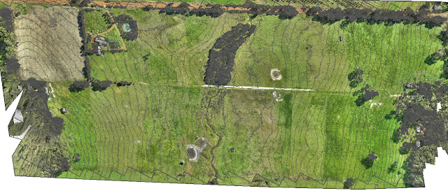
Contour map of 0.5m intervals created with drone imagery

Mission Summary

  • Goal:  To capture drone imagery and demonstrate 0.5m contour lines on a map
  • Tech: Skyray fixed wing drone, Canon S100 camera, Tower app, Drone Deploy
  • Conditions: Midday, stormy
  • Outcome: Producing a detailed contour map, even in difficult weather conditions, was not a problem 

For this project I wanted to demonstrate that we could capture drone imagery using the SkyRay in 'marginal' weather and that we could create a map with contour lines at a far greater level of detail than that attainable from satellite imagery.

Drone contour mapping using Drone Deploy
Processed map in Drone Deploy showing elevation visualisation
We picked a good day as we had storm's rolling in from the south west. This was a little challenging but certainly not something that grounded us. We were able to quite comfortably run 2/3 of the mission and bring the SkyRay in for a landing before the next rain shower hit. This just meant that we had a chance to grab a cuppa and sit by the fire waiting for the weather to clear again. The rain left within 15min and we waited another 10min for the sun to come back out again, we needed this in order to maintain consistency with the previous imagery.

The second flight was no problems, we adjusted the flight plan  slightly in order to get an overlap with the previous flight. Again we managed to finish mapping the entire site before another rain shower came through, all up the entire mission took about 75min including the breaks in between.

Post-processing was a breeze using Drone Deploy and then small adjustments were made in QGIS to produce the contour lines. With this we were able to deliver a map of the 56 hectare site with 0.5m contour lines overlaid on the orthomosaic. Mission successful.

Drone contour mapping using Drone Deploy
3D view of the 56 hectare farm that's been drone mapped 
This has been another 'drone adventure' in aerial surveying, inspection and mapping by The Aero Scout.

Lake Walyungup - 3D map and endurance test

3D map of the north side of Lake Walyungup in the Rockingham area of Perth, WA

Mission Summary

  • Goal:  To test the SkyRay drone for battery endurance whilst mapping a nature reserve
  • Tech: Skyray fixed wing drone, Canon S100 camera, Tower app, Drone Deploy
  • Conditions: Sunny, light wind, midday
  • Outcome: Battery endurance was excellent, 200 acres was mapped no problems

Lake Walyungup, a 430ha salt lake about 8.6km south-east of Rockingham, is popular with many recreational users including land sailors, dog walkers and nature enthusiasts. A shallow saline lake that was once connected to the ocean, Lake Walyungup reaches 3.5 metres at its deepest point. The name Walyungup means 'place where Nyoongars talk'.

Lake Walyungup is an excellent drone testing ground, very large area of mostly flat ground, so I thought I'd see how well the SkyRay went mapping such a large area. It was a sunny day with light winds, 7km/h gusting to 10km/h at ground level, which is just ideal for the SkyRay. We ran through 60% of one battery to cover 97ha, which I was very happy with.

If you look closely at the eastern end you'll see a group of people revegetating the area.

You can see the results below;


If you can't see the 2D map, click here to open it in a new window; http://drdp.ly/FQkzhK


If you can't see the 3D map, click here to open it in a new window; https://skfb.ly/QsUT

This has been another 'drone adventure' in aerial surveying, inspection and mapping by The Aero Scout.

Drainage Channel - Asset Monitoring

Photo positions during a drone mission mapping a drainage ditch

Overview

  • Goal:  Using a drone and aerial photogrammetry to demonstrate how a drainage channel can be surveyed quickly and efficiently for monitoring
  • Tech: Walkera Tali H500 hexacopter drone, Gitup Git2, Tower app, Drone Deploy.
  • Conditions: Light winds, cloudy, cool
  • Outcome: Multicopter drones are a very effective way of surveying, monitoring and recording, in both 2D and 3D the current state of the drain. 

Monitoring utility assets such as a storm water runoff drainage channel is time consuming and expensive. You either have to use satellite (or manned aircraft) imagery which suffers from low resolution and 'timeliness' or you have to send a ground team to walk the full length of the asset and make notes.

In theory, with drone imagery and a service such as Drone Deploy, a one man team can be sent to the field to fly and survey the asset at low altitude. This not only yields a current/up-to-date map in high resolution it has the capability to deliver a 3D model as well.

So I thought I'd put it to the test and headed out during a lunch break with my trusty Tali H500 hexacopter with Gitup Git2 action camera to see how well a drone could produce imagery and then create both a 2D and 3D maps in Drone Deploy.


If you can see the map above, click this link to view in new window; View map here.

You can also view a 3D model of the drain below. Click on the viewer, give it a moment to load and then enjoy moving around a virtual 3D model.


The imagery can also be exported from Drone Deploy to other 'more capable' GIS software packages. From there, and with multiple flights over any given period of time, more sophisticated monitoring can be applied.

This has been another 'drone adventure' in aerial surveying, inspection and mapping by The Aero Scout.

Drone Deploy vs Google Earth Pro

Drone Deploy vs Google Earth
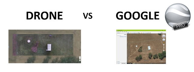
A comparison of drone imagery to Google Earth Pro imagery

Mission Summary

  • Goal: To compare Google Earth Pro to Drone Deploy 
  • Tech: Walkera Tali H500 hexacopter drone, Gitup Git2 actioncam, Tower app, Drone Deploy
  • Conditions: Early arvo, Windy, Scattered cloud
  • Outcome:  Drone Deploy gives more features to use on a higher resolution map when compared to Google Earth Pro.

I thought I'd follow up the previous article comparing drone imagery with Google maps with a new comparison of the features in Drone Deploy and Google Earth Pro.

Google Earth Pro recently became a free service and is widely been used as an excellent 'planning tool' for making basic measurements of distance and area based on aerial imagery.

Find below examples of drone imagery I had taken of the shearing shed on the farm turned into a 2D map created with Drone Deploy from a survey I made using my Tali H500 hexacopter with Gitup Git2 action camera. I'll compare this imagery to Google Earth Pro at the same location.

Drone Deploy vs Google Earth
View of the shearing shed from 2D map in Drone Deploy created using drone images.


Drone Deploy vs Google Earth
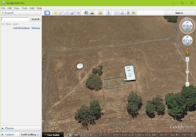
View of the shearing shed from Google Earth Pro, note the level of detail is not the same as drone images above.


Drone Deploy vs Google Earth
One of basic tools is the 'marker' . Add a note of use it to get GPS co-ords of a small point.

Drone Deploy vs Google Earth
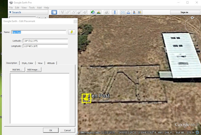
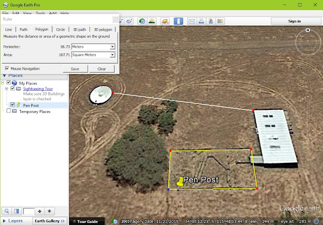
Google Earth Pro's version of the same marker tool. Does the same job, it's just harder to place on a small object.


Drone Deploy vs Google Earth
Measure distance between two or more objects in Drone Deploy 

Drone Deploy vs Google Earth
Measure distance between objects in Google Earth Pro


Drone Deploy vs Google Earth
Measure area in Drone Deploy

Drone Deploy vs Google Earth
Measure area in Google Earth Pro

Drone Deploy vs Google Earth
Screen showing multiple annotations in Drone Deploy.
The above are the most basic tools from Drone Deploy and the majority of the tools available in Google Earth Pro. You'll noticed that not only are the drone images used in Drone Deploy are of a higher resolution (meaning you can zoom in closer) but it is also a current map. The drone images were taken only a week ago, I'd say that the Google Earth Pro images would have been taken 6 months ago.

See below for extra features available in Drone Deploy.

Drone Deploy vs Google Earth
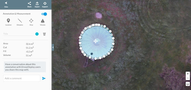
Volumetric tool, not the best example of how to use it but the only applicable one for this mission.

Drone Deploy vs Google Earth
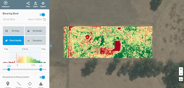
The 'Plant Health' tool (in this example) is based on RGB images and therefore not as sensitive as other methods, but still a useful tool.


Drone Deploy vs Google Earth
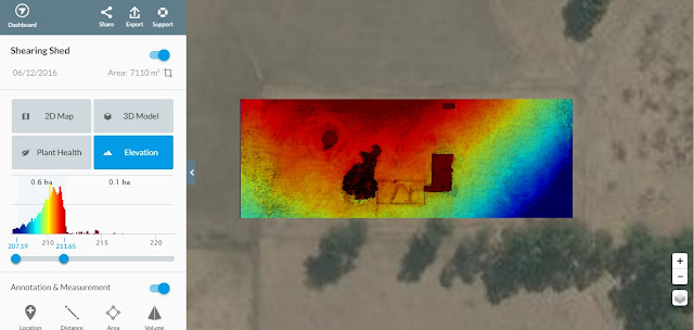
The 'Elevation' tool gives a colour gradient to heights on the map. A contour tool will hopefully be added as a feature sometime soon too.


Drone Deploy vs Google Earth
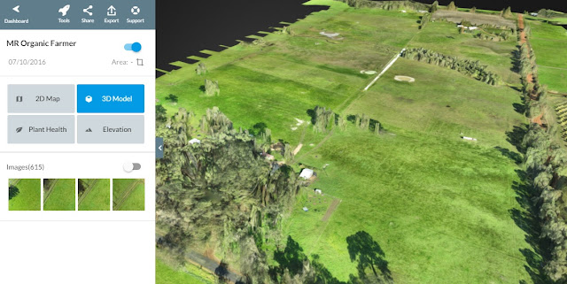
A 3D model is also generated, great for getting a better understanding of the area mapped.
It's not hard to see that whilst Google Earth Pro has some great 'basic' features, Drone Deploy has many more tools that really turn an online map into a functional planning tool.

This has been another 'drone adventure' in aerial surveying, inspection and mapping by The Aero Scout.